Here is the translation of the entire provided text:
Organized routes for visiting the Great Wall, with hand-drawn strategy maps, and you can mix and match freely! 💰 Ticket price: 40, half price for students ⏰ Time spent on the Great Wall 👉 Round-trip on foot: about 1.5h for the south route and 2.5h for the north route 👉 Cable car to the 8th floor: about 5 minutes 🚗 Transportation guide 1⃣ High-speed rail: Qinghe → Badaling Great Wall, 0.5h, ¥17 2⃣ Bus: From Qianmen Station 6:30-11:00, return from Badaling Scenic Area 11:00-16:00 3⃣ Public transportation: Deshengmen → Badaling, Route 877, 1.5h 4⃣ Suburban S2 line: Huangtudian → Badaling, 1h, ¥7 5⃣ Driving: Jingzang Expressway to Heilongtan Parking Lot, ¥24, with free shuttle bus to the pedestrian street (for walking to the Great Wall) or cable car entrance ❤️ Tips: After exiting, turn left for the pedestrian route, which takes a few minutes, and turn right for the cable car (there are signs on site, follow the signs); the bus returning from Badaling Scenic Area stops at "Deshengmen", and if you want to go to the Bird's Nest Water Cube, you can get off at "Deshengmen" and take the subway.
———————
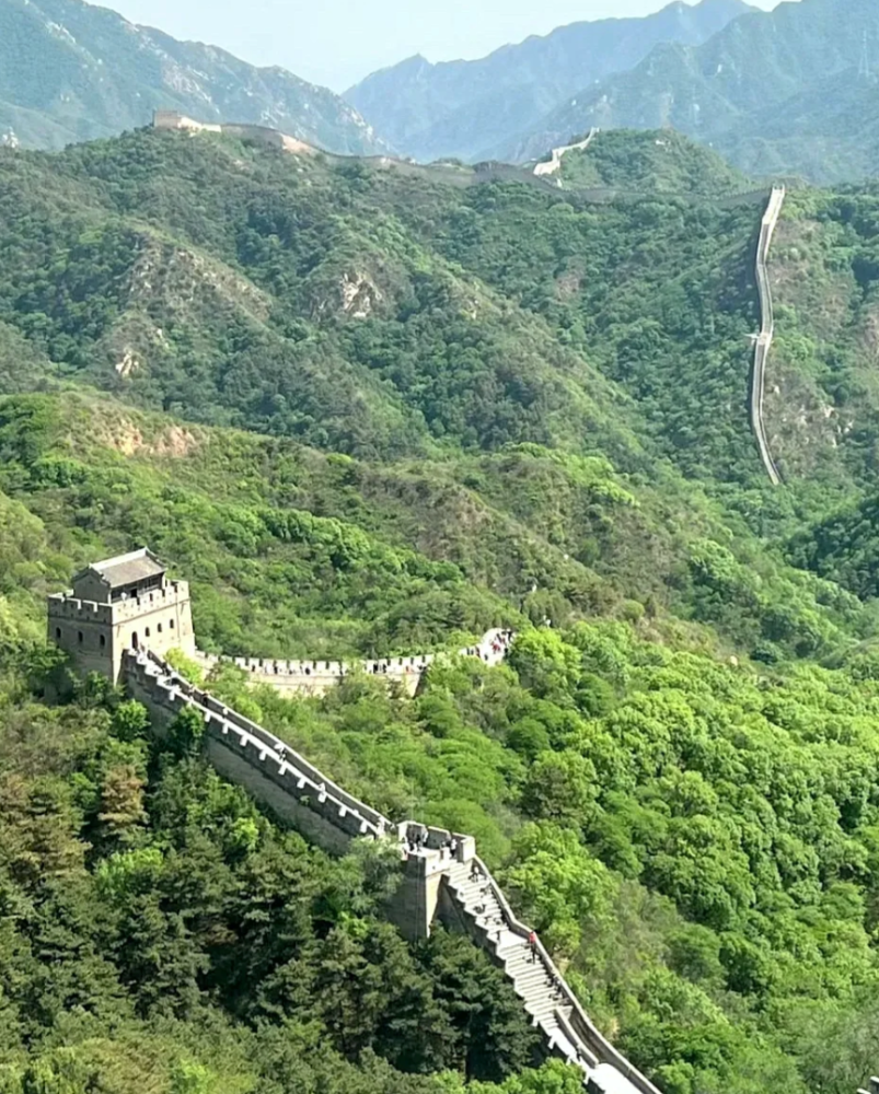
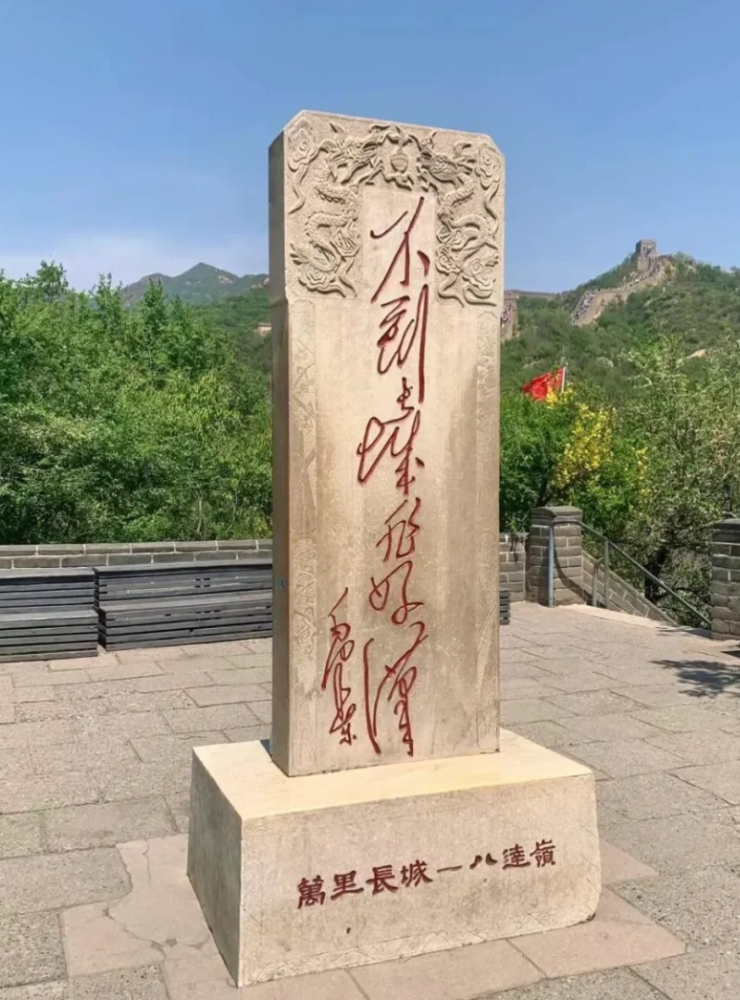
🌈 Great Wall situation 1⃣ The north wall has 12 sections, and the south wall has 7 sections (the south wall is relatively flat) 2⃣ The Hero Stone is on the north wall (north 4), and the Hero Tablet is on the south wall (south 1, 2, and 4 all have)
🌟 Climbing the Great Wall tools 📌 Cable car: single trip ¥100, round trip ¥140 📌 Slide: ¥80
———————
✅ Classic route Route 1️⃣: Easy hero 🚩 Cable car entrance → Cable car up to North 7 → Walking to North 8 → Walking back to North 7 → Cable car down Route 2️⃣: Tooling up 🚩 Cable car entrance → Cable car up to North 7 → Walking to North 8 → Walking back to North 4 → Slide down → Black Bear Park → Walking exit Route 3️⃣: North and south comprehensive plan | Cable car scheme 🚩 Pedestrian entrance → Walking from South 1 to South 7 → Walking back to South 1 → Walking from North 1 to North 8 → Walking back to North 7 → Cable car down Route 4️⃣: North and south comprehensive plan | Slide scheme 🚩 Pedestrian entrance → Walking from South 1 to South 7 → Walking back to South 1 → Walking from North 1 to North 8 → Walking back to North 4 → Slide down Route 5️⃣: Real power player 🚩 Pedestrian entrance → Walking from South 1 to South 7 → Walking back to South 1 → Walking from North 1 to North 12 → Walking back to North 11 → Black Bear Park → Walking exit
———————
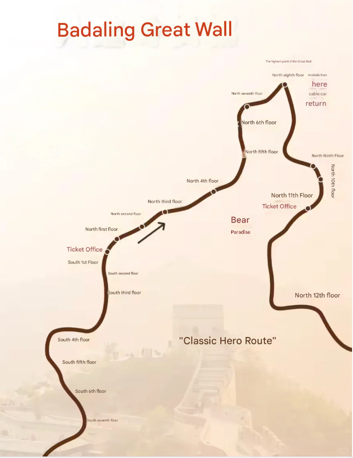
📷 Great Wall check-in ✅ North 4th floor: Hero Stone ✅ North 6th floor: Aerial Cable Car ✅ North 8th floor: Hero Slope ✅ North 10th floor: Flowers or Red Leaves ✅ North 12th floor: Full view of the Great Wall, Guanting Reservoir ✅ South 1st floor: Hero Tablet ✅ South 4th floor: Full view of the North Wall ✅ South 6th floor: Pine and Cypress
Sign in to join the conversation
Sign InNo comments yet. Be the first to share your thoughts!
A special administrative region in southern China, it is an international financial center and shopping paradise.
An important port city and industrial base in northern China, with a unique colonial architectural style.
China's southernmost province is a tropical island resort.
An autonomous region in southwestern China, famous for its plateau scenery and Tibetan Buddhist culture.
Guangzhou City (Guangzhou City, Canton [166]), referred to as "Sui", also known as Yangcheng, Huacheng, and Wuyangcheng, [162] is a prefecture-level city, provincial capital, sub-provincial city, national central city, megacity, [53] a world-class city under the jurisdiction of Guangdong Province. It is located in the south-central part of Guangdong Province and the northern edge of the Pearl River Delta [46] [81], with a total area of 7,434.40 square kilometers [1] [14]. The common languages are Cantonese and Mandarin. [35] As of March 2025, Guangzhou City has 11 districts under its jurisdiction. As of the end of 2024, Guangzhou City has a permanent population of 18.978 million. [448] Guangzhou City has a significant marine climate, and both the ocean and the continent have a significant impact on Guangzhou's climate. [115] [116] Guangzhou City is a hilly area, with high terrain in the northeast and low terrain in the southwest. [34] As early as the Neolithic period six or seven thousand years ago, our ancestors lived and multiplied on this land. [82] The city of Guangzhou in the Qin Dynasty was named Renxiao City because it was built by the Qin general Renxiao. Its official name is Panyu City. [113] In the third year of Shunzhi in the Qing Dynasty (1646), Zhu Yuanzhang's descendants proclaimed themselves emperors in Guangzhou, with the reign title "Shaowu". This was known as the "Southern Ming" regime, which lasted only 40 days. [113] On October 14, 1949, Guangzhou was liberated and became a centrally administered municipality. In 1950, it was changed to the leadership of the Central South Military and Political Committee. In 1954, it was transferred to the leadership of Guangdong Province and became a provincial-level city. In 1994, it was upgraded to a sub-provincial city. [226] Guangzhou is the core city of the Guangzhou Metropolitan Area. It is an important central city, international trade center and comprehensive transportation hub in China approved by the State Council. [80] It is an international trade center, a national advanced manufacturing base, a comprehensive portal, and an important carrier of the international science and technology innovation center. [76] [169] [413] Guangzhou's main industries are shipping services, science and technology services, special finance, international trade, professional services and other productive services. [125] Guangzhou is one of the first national historical and cultural cities, one of the starting points of the Maritime Silk Road, and is known as the "Millennium Commercial Capital". It has been a place where Chinese and foreign cultures have blended since ancient times, one of the birthplaces of Cantonese culture, and the headquarters of China's Southern Theater Command. [170-171] In 2024, Guangzhou's GDP will be 3,103.25 billion yuan, an increase of 2.1% over the previous year at comparable prices.
Introduction to Changping District Changping District is a district in the northwestern part of Beijing, China. Here’s an overview of the district: Geography and Location Situated in the northwestern suburbs of Beijing, it borders Yanqing District and Mentougou District to the west, Huairou District and Miyun District to the north, Shunyi District to the east, and Haidian District and Changping District to the south. The terrain is diverse, with mountainous areas in the north and plains in the south. The Jundu Mountains run through the district, providing a natural barrier and scenic landscapes. History and Culture Changping has a long history dating back to the Western Zhou Dynasty (1046–771 BCE). It has been an important military and transportation hub since ancient times. It is home to several significant cultural and historical sites: Badaling Great Wall: One of the most iconic and best-preserved sections of the Great Wall, attracting millions of tourists worldwide. Ming Tombs (Ming Changling): A UNESCO World Heritage Site featuring the mausoleums of 13 Ming Dynasty emperors, showcasing ancient architectural and cultural excellence
Lijiang City, [21] is a prefecture-level city under the jurisdiction of Yunnan Province, China. It borders Liangshan Yi Autonomous Prefecture and Panzhihua City in Sichuan Province to the east, Jianchuan, Heqing, and Binchuan counties of Dali Bai Autonomous Prefecture and Dayao and Yongren counties of Chuxiong Yi Autonomous Prefecture to the south, Lanping County of Nujiang Lisu Autonomous Prefecture to the west and Weixi County of Diqing Tibetan Autonomous Prefecture to the north. [131] Lijiang City has a total area of 20,600 square kilometers, [132] and has one district and four counties under its jurisdiction. [19] Naxi, Mosuo, Yi, and Yunnan dialects are spoken in the city. [54] [119] As of the end of 2024, the permanent population of Lijiang City is 1.25 million. [220] Lijiang City is located on the southeastern edge of the Qinghai-Tibet Plateau, the northwest Yunnan Plateau, [20] and has a semi-humid low-latitude plateau mountain monsoon climate. [30] The rivers in the territory belong to two major river basins and three major water systems. In the Shu Han period, Lijiang was established as Suijiu County. In the Yuan Dynasty, the Chahanzhang Civil Affairs Office was first established, and later changed to Lijiang Xuanweisi, Lijiang Road Military and Civil Administration Office. In the early Ming Dynasty, Lijiang Prefecture was established. In the Qing Dynasty, Lijiang Military and Civil Affairs Office was established. In December 1949, Lijiang People's Administrative Commissioner's Office was established, and in April 1950, it was changed to Lijiang Commissioner's Office. [5] Lijiang City has an integrated comprehensive transportation system with roads as the main body, and railways, civil aviation, and water transportation connected. The transportation in the territory is convenient. [90] It is the political, economic and cultural center of northwest Yunnan, and a distribution center for materials on the "Southern Silk Road" and the "Ancient Tea Horse Road". [5] Lijiang City has three world heritage sites, [201] multi-ethnic and multi-religious coexistence, [29] above-ground and underground cultural relics are widely distributed, [128] and rich tourism resources. [59] As of 2021, there are 199 fourth-level cultural relics protection units. There are 11 national-level sites, 14 provincial-level sites, 56 municipal-level sites, and 118 county (district)-level sites. [11] There are 104 tourist attractions in the territory, with more than 13,000 species of animals and plants, making it one of the country's famous animal and plant protection bases. [219] Lijiang City has a variety of ethnic cultures and folk activities. For example, the Bangbang Festival and the Sanduo Festival of the Naxi people on the 15th day of the first lunar month, the Torch Festival of the Yi people, and the Kuoshi Festival of the Lisu people. [59] In 2024, Lijiang City will achieve a regional GDP of 71.003 billion yuan, an increase of 4.7% over the previous year.
Urumqi (Uyghur: ئۈرۈمچى شەھىرى, Latin Uyghur: Ürümchi shehiri)[Note 1], also known as Urumqi for short, formerly known as Dihua, is the capital of the Xinjiang Uyghur Autonomous Region of the People's Republic of China, an important central city in the western region, and an international comprehensive transportation hub city[2]. It is the second largest city in the northwest region[3][4], the core city of the Silk Road Economic Belt, the New Eurasian Continental Bridge and the Tianshan North Slope Urban Agglomeration[5]. It is also the political, economic, cultural, financial, transportation, medical and educational center of Xinjiang, as well as a communication center facing Central Asia and West Asia and an international trade and logistics center. It has a UNESCO World Heritage Site in Xinjiang Tianshan[6]. The Municipal People's Government is located at No. 72, Nanhu Road, Shuimogou District. Urumqi is located in the central part of Xinjiang, bordering Changji Prefecture on the east and west, Turpan City in the southeast, Bayingolin Prefecture in the southwest, Wujiaqu City in the northwest, and Altay Prefecture in the north. It is located at the northern foot of the middle section of the Tianshan Mountains and the southern edge of the Junggar Basin. It is surrounded by mountains on the east, south and west. The terrain is high in the south and low in the north. There are Bogda Mountain in the east, Tianger Mountain in the south, Kalaza Mountain in the west, and the Gurbantunggut Desert in the north. There are rivers such as the Urumqi River, Toutun River, and Baiyang River in the territory. As of 2019, the city has jurisdiction over 7 districts and 1 county, with a total area of 14,216.3 square kilometers, of which the built-up area of the city has reached 521.60 square kilometers[7], making it the largest city in Central Asia. The city is also certified by the Guinness Book of Records as the largest city in the world farthest from the ocean (2,500 kilometers)[8][9]. According to the seventh census data, as of November 1, 2020, the permanent population of Urumqi was 4,054,369. The Han nationality accounts for about 76%, the Uyghur nationality accounts for about 11%, and the Hui nationality accounts for about 9%. The local fiscal revenue for the whole year was 69.354 billion yuan. [10] Urumqi is a national civilized city, a national garden city, a national model city for supporting both the army and the people, an excellent tourist city in China, and a national model city for ethnic unity and progress[11]. It is one of the top 100 best commercial cities in mainland China. It has won the title of "China's Top Ten Ice and Snow Tourism Cities" for six consecutive years since 2016.