First of all, it is impossible not to be tired! The average daily step is 20,000+. The three main players are both amateur and fun-loving. The good thing about traveling during the Mid-Autumn Festival is that the overall flow of people is okay, and the queue is within half an hour. Let me talk about the arrangement of the two-day tour (the first day is up the mountain, the second day is down the mountain). The check-in points can be seen in the corresponding pictures.
🎫: For a two-day tour, you can choose the three-cable and one-elevator package with your eyes closed. The scenic area is full of facial recognition, which is very convenient.
Day1 (on the mountain) East Gate entry-Bailong Elevator (up the mountain)-Yuanjiajie-Yangjiajie-Tianzi Mountain-Tianzi Mountain Cableway (down the mountain) East Gate exit
1️⃣Bailong Elevator
Enter the East Gate and take the environmental protection for 20 minutes through the Ten-mile Gallery (don't get off the car) to the lower station of the ladder.
I have watched too many videos online, and I am unwilling to take it. It's just like that after taking it, but it can achieve a quick mountain climb!
It takes about 20 minutes to get to Yuanjiajie after getting out of the elevator and taking the environmental protection car.
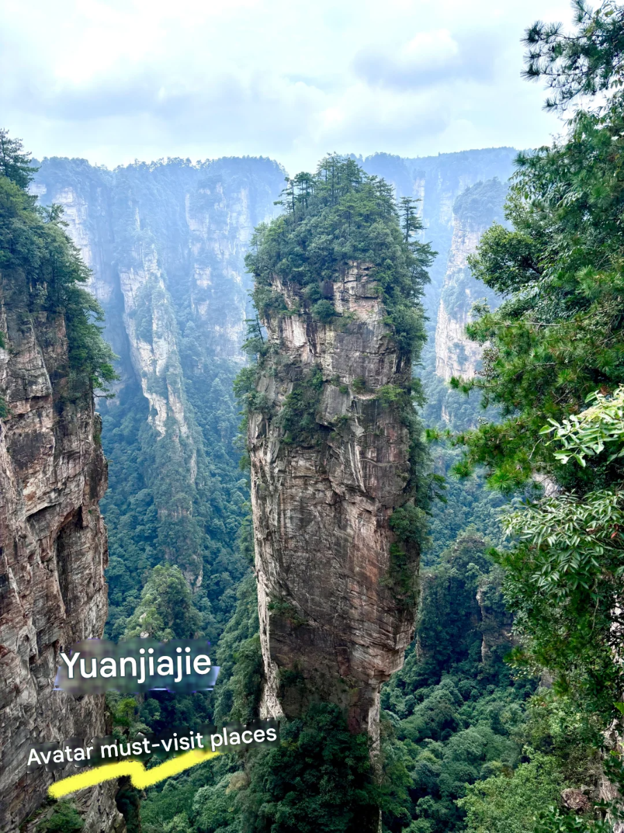
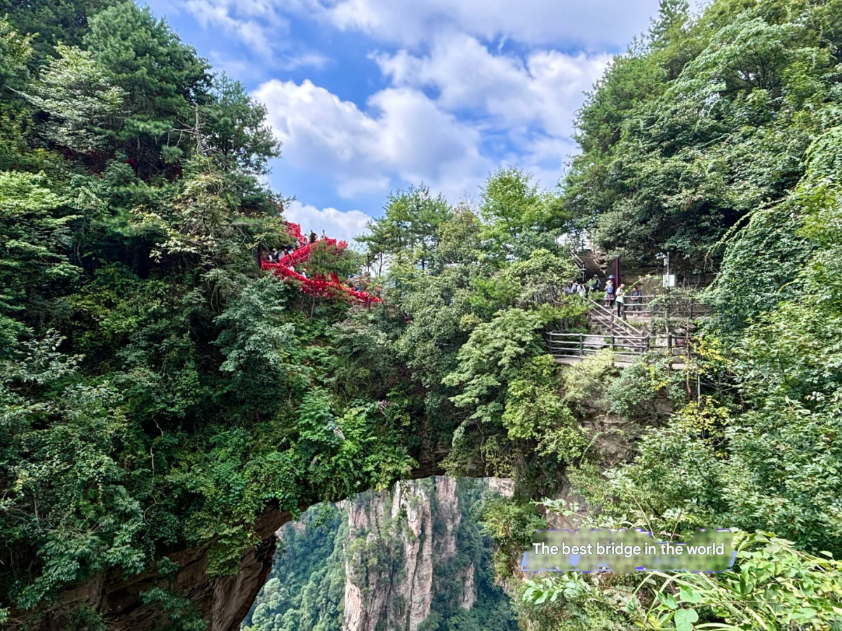
2️⃣Yuanjiajie
I would like to call it the most shocking place in the whole Zhangjiajie.
Enter from the Mihun Terrace, there is a pillar of heaven and earth in the middle (the filming location of Avatar), see the hundred-yuan bill, and finally exit at the No. 1 Bridge in the World.
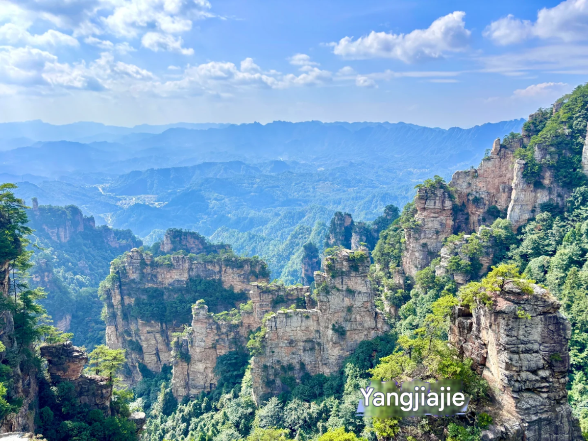
Take the eco-friendly car for about 10 minutes to Yangjiajie.
3️⃣ Yangjiajie (optional) is a bit mediocre, some attractions are too far away and there is no time
Take the eco-friendly car for about 20 minutes to Tianzi Mountain
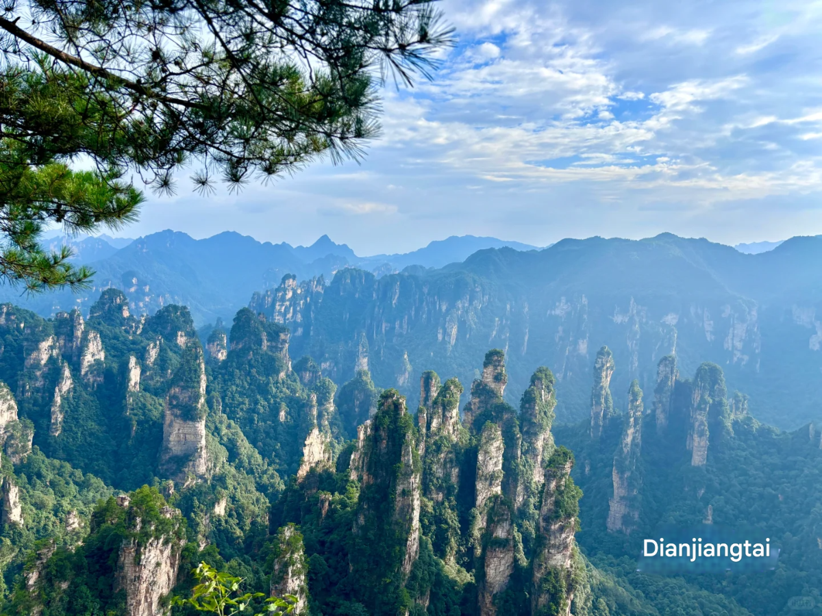
4️⃣ Tianzi Mountain
⚠️ Be sure to tell the driver on the eco-friendly car that you want to get off at [Dianjiangtai], otherwise you will be taken all the way to Tianzi Mountain. The scenery of Dianjiangtai is definitely better. We also took the car back after arriving.
After watching the Imperial Brush Peak and Fairy Offering Flowers at Tianzi Mountain, you can take the cable car down the mountain.
Day 2 (down the mountain) Enter from the South Gate - Oxygen Bar Square - Huangshi Village → Golden Whip Stream - Ten-mile Gallery - Exit from the East Gate
1️⃣Huangshi Village 2h Tour
We decided to walk through Golden Whip Stream, so we only walked a small circle in Huangshi Village to save our energy. The map of the scenic area shows the large circle (3-4h) and the small circle (1-2h). The core attractions are basically enough for the small circle, mainly because we were a little tired of seeing the mountain on the second day
2️⃣Golden Whip Stream (4h)
The whole journey is 7.5 kilometers. To be honest, I really couldn't walk at the end... But the air and environment are really great, and it doesn't feel hot. Many people who eat snacks are super cute.
3️⃣Ten-mile Gallery (1h)
We chose to take the train in and walk out. The total length is 2 kilometers. The train needs to buy a separate ticket. The main reason is that my smart mother chose to listen to the explanation on the train and then take pictures when she walked out. Otherwise, it's a bit hard to tell which mountain to look at just by looking at the signboards.
⚠️tips
1️⃣Time: If you only play for one day, it is recommended to go to Bailong Ladder-Yuanjiajie-Yangjiajie Lower-Jinbianxi. If you don't have enough energy and have more time, you can choose a three-day tour
2️⃣A lot of ⛰️ need to rely on imagination, but it really looks more and more like it, and it's still worth the trip~
3️⃣ Be sure to wear comfortable shoes! Look at the signboards and avoid taking the wrong road
Sign in to join the conversation
Sign InNo comments yet. Be the first to share your thoughts!
Lijiang City, [21] is a prefecture-level city under the jurisdiction of Yunnan Province, China. It borders Liangshan Yi Autonomous Prefecture and Panzhihua City in Sichuan Province to the east, Jianchuan, Heqing, and Binchuan counties of Dali Bai Autonomous Prefecture and Dayao and Yongren counties of Chuxiong Yi Autonomous Prefecture to the south, Lanping County of Nujiang Lisu Autonomous Prefecture to the west and Weixi County of Diqing Tibetan Autonomous Prefecture to the north. [131] Lijiang City has a total area of 20,600 square kilometers, [132] and has one district and four counties under its jurisdiction. [19] Naxi, Mosuo, Yi, and Yunnan dialects are spoken in the city. [54] [119] As of the end of 2024, the permanent population of Lijiang City is 1.25 million. [220] Lijiang City is located on the southeastern edge of the Qinghai-Tibet Plateau, the northwest Yunnan Plateau, [20] and has a semi-humid low-latitude plateau mountain monsoon climate. [30] The rivers in the territory belong to two major river basins and three major water systems. In the Shu Han period, Lijiang was established as Suijiu County. In the Yuan Dynasty, the Chahanzhang Civil Affairs Office was first established, and later changed to Lijiang Xuanweisi, Lijiang Road Military and Civil Administration Office. In the early Ming Dynasty, Lijiang Prefecture was established. In the Qing Dynasty, Lijiang Military and Civil Affairs Office was established. In December 1949, Lijiang People's Administrative Commissioner's Office was established, and in April 1950, it was changed to Lijiang Commissioner's Office. [5] Lijiang City has an integrated comprehensive transportation system with roads as the main body, and railways, civil aviation, and water transportation connected. The transportation in the territory is convenient. [90] It is the political, economic and cultural center of northwest Yunnan, and a distribution center for materials on the "Southern Silk Road" and the "Ancient Tea Horse Road". [5] Lijiang City has three world heritage sites, [201] multi-ethnic and multi-religious coexistence, [29] above-ground and underground cultural relics are widely distributed, [128] and rich tourism resources. [59] As of 2021, there are 199 fourth-level cultural relics protection units. There are 11 national-level sites, 14 provincial-level sites, 56 municipal-level sites, and 118 county (district)-level sites. [11] There are 104 tourist attractions in the territory, with more than 13,000 species of animals and plants, making it one of the country's famous animal and plant protection bases. [219] Lijiang City has a variety of ethnic cultures and folk activities. For example, the Bangbang Festival and the Sanduo Festival of the Naxi people on the 15th day of the first lunar month, the Torch Festival of the Yi people, and the Kuoshi Festival of the Lisu people. [59] In 2024, Lijiang City will achieve a regional GDP of 71.003 billion yuan, an increase of 4.7% over the previous year.
Kashgar City (Uyghur: قەشقەر شەھىرى) [10] is a county-level city under the jurisdiction of Kashgar Prefecture, Xinjiang Uyghur Autonomous Region. It is located in the southwest of Xinjiang Uyghur Autonomous Region and the western edge of the Tarim Basin. The terrain is high in the north and low in the south. It has a warm temperate continental arid climate with four distinct seasons and a total area of 1,528.84 square kilometers. [11] As of 2024, Kashgar City has 10 sub-districts, 3 towns, and 12 townships. As of August 2020, Kashgar City has a permanent population of 700,000. [20] Kashgar is the abbreviation of "Kashgar". "Kashgar" means "jade" in Turkic and "Gar" means "stone" or "mountain" in ancient Iranian. Before Kashgar was incorporated into the territory of the Central Plains regime, it was often part of the Shule Kingdom. It was not until Zhang Qian's mission to the Western Regions that official exchanges between Kashgar and the Central Plains began. In the third year of Yongping in the Eastern Han Dynasty (60 AD), the Western Regions Protectorate was established, and Kashgar, as part of the Western Regions, was officially included in China's territory. In 1952, Kashgar City was officially established. Kashgar City is a national historical and cultural city, a national open city, an excellent tourist city in China, and a national model city for the military-civilian integration. It is the westernmost border city in China and the political, economic and cultural center of the Kashgar region. It is an important commercial port on the Silk Road, a hub for east-west transportation, and an important intersection of the economy, culture and civilization of the East and the West. Kashgar International Airport is a first-class aviation port open to the outside world. In October 2020, Kashgar City was named a national model city for the military-civilian integration. [1] In 2023, Kashgar City achieved a gross domestic product (GDP) of 30.931 billion yuan, an increase of 9.6% over the previous year.
Dali City (Bai: Dallit sil) is a county-level city in Dali Bai Autonomous Prefecture, Yunnan Province, People's Republic of China, and is also the capital of Dali Prefecture. It is located in the western part of Yunnan Province, China, on the Yunnan-Guizhou Plateau, at the foot of Cangshan Mountain, and on the shore of Erhai Lake. The city covers an area of 1,739 square kilometers, with a total population of 771,100 in 2020. The Municipal People's Government is located in Haidong Town. Dali City is a national historical and cultural city[6], an excellent tourist city in China, a national garden city[7], and a national comprehensive tourism demonstration area[8]. In ancient times, it was the capital of Nanzhao Kingdom and Dali Kingdom successively. It is one of the earliest developed regions in Yunnan Province and has served as the political, economic and cultural center of Yunnan for more than 500 years.
The political and cultural center of Beijing, with many government agencies and cultural institutions. Xicheng District, under the jurisdiction of Beijing, is located in the central area of western Beijing. It is adjacent to Dongcheng District in the east; Haidian District and Chaoyang District in the north; Haidian District and Fengtai District in the west; and Fengtai District in the south. The district is 7.1 kilometers wide from east to west and 11.2 kilometers long from north to south, with a total area of 50.70 square kilometers. As of January 2025, Xicheng District has 15 sub-districts and 263 communities under its jurisdiction [39] [66]. As of the end of 2024, the permanent population of Xicheng District is 1.095 million. [70] Xicheng District is the site of Jicheng, the capital of Yan during the Warring States Period, and was part of the capital during the Liao, Jin, Yuan, Ming and Qing dynasties. As the place where Beijing was built for more than 3,000 years and the capital for more than 800 years, it is a fusion area of royal culture and folk culture, and an area where various cultures such as imperial city culture, official culture, folk culture, and religious culture are highly integrated [2]. Xicheng District has many scenic spots, including Yuetan Park, Temple of Successive Emperors, Taoranting Park, Beijing Grand View Garden, Prince Chun Garden, Prince Gong Mansion Garden, etc. In 2024, Xicheng District will achieve a GDP of 603.8 billion yuan, of which the added value of the secondary industry is 30.27 billion yuan and the added value of the tertiary industry is 573.54 billion yuan. Calculated based on the permanent population, the per capita GDP of the district is 550,000 yuan (converted to 77,000 US dollars at the annual average exchange rate).
China's southwestern province is famous for its Sichuan cuisine, giant pandas and rich natural scenery.
A coastal province in eastern China with a developed economy and world cultural heritage sites such as Suzhou Gardens.
China's largest economic center and international metropolis, integrating Eastern and Western cultures.
An autonomous region in southern China, famous for its Guilin landscape and ethnic minority culture.