✅Route arrangement
Enter from Beiruyi Gate → Binfeng Bridge (West Bank) → Tour in the Painting → Buddhist Incense Pavilion → Zhichun Pavilion → Seventeen-Arch Bridge → Nanhu Island Hanxu Hall → Exit from Xinjian Palace Gate
⏰ Recommended tour duration: 3-5 hours
Student ticket: 💰20
You need to buy a separate ticket for Buddhist Incense Pavilion💰10
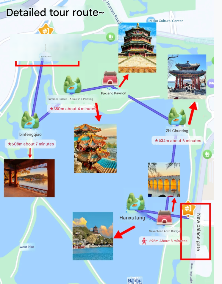
✅Detailed route planning
📍Enter the park from Beiruyi Gate: Get off at Beigongmen Station on Metro Line 4, walk about 1.2 kilometers or take a taxi (no direct bus).
‼ ️Note: There is no storage point at Beiruyi Gate, it is recommended to travel light
⬇️Walk for 10 minutes
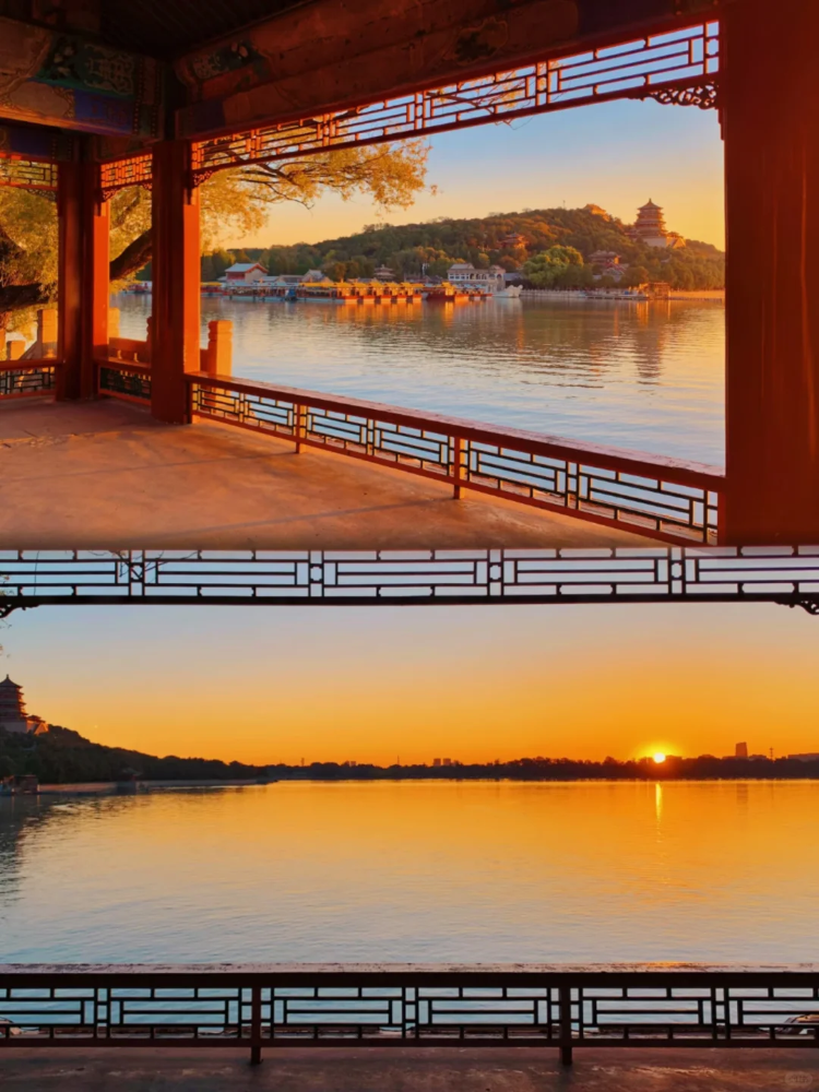
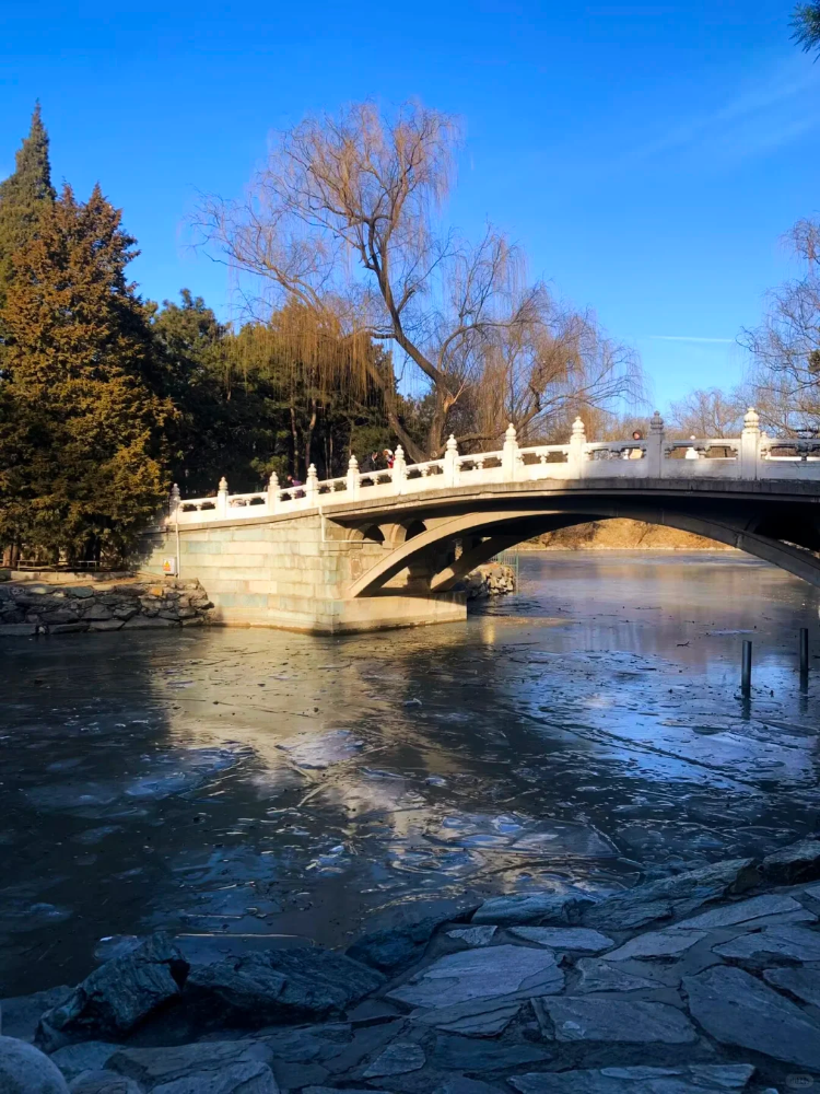
📍2. Binfeng Bridge: It is one of the six bridges on West Bank. Its name is taken from the agricultural poem in the Book of Songs. The bridge is simple and quaint. You can enjoy peach blossoms in spring and withered lotus in autumn. It is a beautiful sight in all seasons. Walking south along the West Embankment, you can overlook Kunming Lake and Yuquan Mountain, and feel the essence of the art of "borrowing scenery" gardening.
⬇️Walk for 18 minutes (circle back to the North Ruyi Gate)
📍Tour in the painting: The building complex is built on the mountain, with octagonal pavilions and corridors scattered around. After climbing to the top, you can overlook the panoramic view of Kunming Lake. It is one of the best photo spots in the Summer Palace. Legend has it that this place was inspired by the Jiangnan landscape in Qianlong's dream, and it is suitable for wearing Hanfu to shoot ancient style blockbusters.
⬇️Walk for 5 minutes
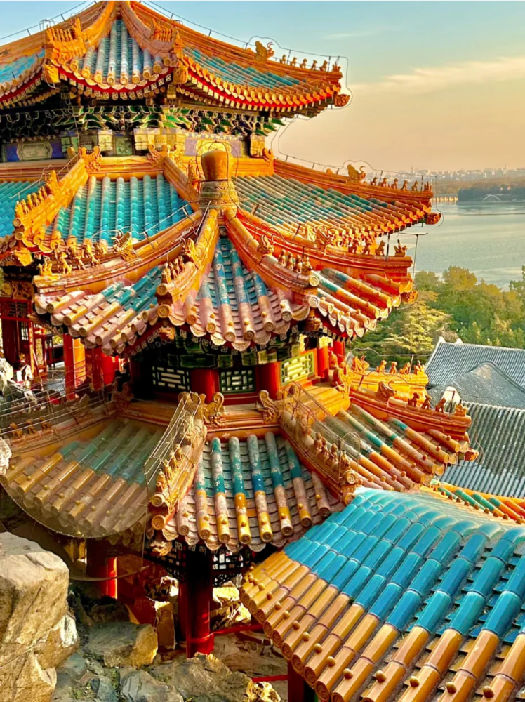
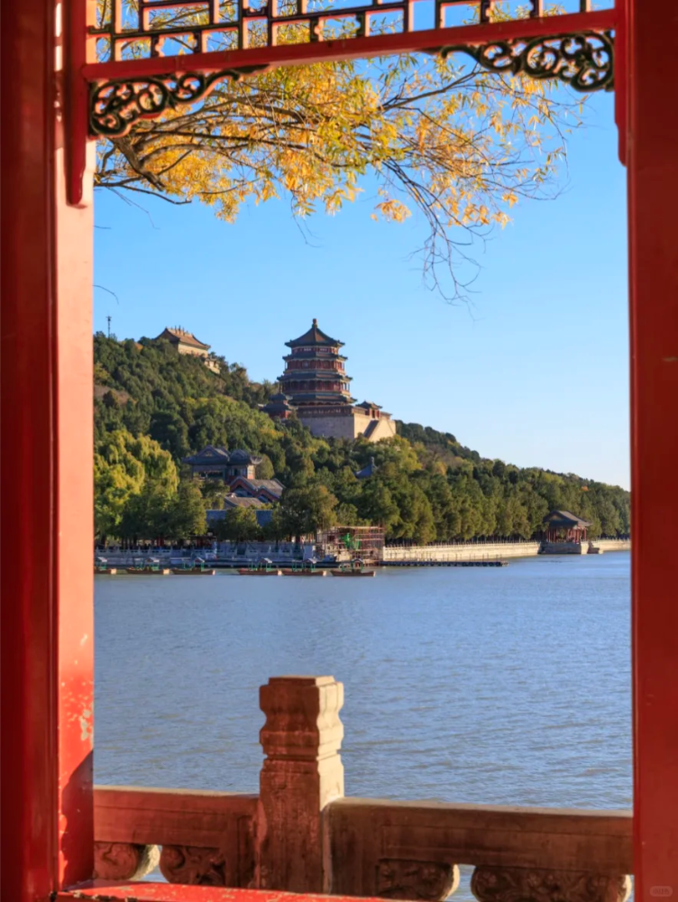
📍 Buddha Incense Pavilion: The iconic eight-sided three-story pavilion, 41 meters high, enshrines the gilded statue of Thousand-armed Guanyin, and you can see the lake and mountain scenery of the whole park when you climb to the top.
‼ ️Note: You need to buy a separate ticket for the Buddhist Incense Pavilion (10 yuan). It is recommended to buy a combined ticket (including Suzhou Street, Dehe Garden, etc.) for a better deal.
⬇️Walk for 18 minutes
📍 Zhichun Pavilion: The name of the pavilion is taken from "The duck knows first when the spring river is warm", which is a good place to watch the reflection of Wanshou Mountain and the scenery of lakes and mountains. The view here is wide, suitable for taking classic pictures of the Buddhist Incense Pavilion and Kunming Lake in the same frame
⬇️Walk for 15 minutes
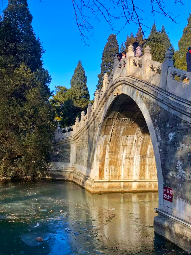
📍 6 Seventeen-hole Bridge and Nanhu Island: The total length is 150 meters. The 17 holes on the bridge body symbolize the changes in the moon. The 544 stone lions at the bridge head have different postures. In the evening, the setting sun passes through the bridge hole to form the wonder of "golden light through the hole".
⬇️1min walk
📍Hanxu Hall: the main building of Nanhu Island, once the place where Empress Dowager Cixi reviewed the navy, now a viewing platform, overlooking the West Embankment and Yuquan Mountain
⬇️5min walk
📍Newly built palace gate: close to Xiyuan subway station, bus 74/374/43 directly, convenient for return or to the surrounding attractions such as Yuanmingyuan, Tsinghua University and Peking University.
Sign in to join the conversation
Sign InNo comments yet. Be the first to share your thoughts!
Wuxi City, referred to as "Xi", is a prefecture-level city under the jurisdiction of Jiangsu Province. It is a Type I large city [139] and is located in the eastern part of China and the southern part of Jiangsu Province. It is adjacent to the Yangtze River in the north, Taihu Lake in the south, Suzhou City in the east, Changzhou City in the west, Huzhou City in Zhejiang Province and Xuancheng City in Anhui Province in the south and southwest. It is a city in the central area of the Yangtze River Delta [6] and a member city of the Shanghai Metropolitan Area [140]. The Beijing-Hangzhou Grand Canal passes through the city, with a total area of 4,627.46 square kilometers [122]. The territory is mainly plains, with scattered low mountains and residual hills. It belongs to the northern subtropical humid monsoon climate zone. As of the end of 2023, the city has jurisdiction over 5 districts and administers 2 county-level cities; the city's permanent population is 7.495 million. [51] [105] Wuxi City is an important birthplace of Jiangnan civilization and Wu culture. Legend has it that it was named Wuxi because the tin mines in Xishan were exhausted. There are written records of this in the late Shang Dynasty. In the fifth year of Emperor Gaozu of the Western Han Dynasty (202 BC), Wuxi County was established and belonged to Kuaiji County. In the second year of Taikang of the Western Jin Dynasty (281 AD), it belonged to Piling County. Since the 16th year of the Republic of China (1927), it has been directly under the jurisdiction of Jiangsu Province. After Wuxi County was liberated on April 23, 1949, it was divided into Wuxi City and Wuxi County. In 1953, Jiangsu Province was established and Wuxi City became a provincial-level city. On March 1, 1983, the city-county system was implemented and Jiangyin, Yixing and Wuxi counties were placed under the jurisdiction of Wuxi City. [135] Wuxi City is an important central city in the Yangtze River Delta region approved by the State Council, a national historical and cultural city, a national comprehensive transportation hub city, a national advanced manufacturing base, a regional highland of scientific and technological innovation and a cultural and creative base, and a scenic tourist destination with lakeside landscape characteristics. [82] Wuxi City is the main birthplace of modern Chinese national industry and commerce, township enterprises, and the "Southern Jiangsu Model". It has landmark industries such as the Internet of Things, integrated circuits, and biomedicine. Wuxi has a strong cultural atmosphere and is the birthplace of historical celebrities such as Qian Zhongshu, Qin Bangxian, Rong Yiren, Abing, and Xu Beihong. [136] In 2024, Wuxi's GDP will reach 1,626.329 billion yuan, a year-on-year increase of 5.8% at constant prices.
Xi'an, formerly known as Haojing, Chang'an, Jingzhao, Xijing, and Yongzhou, is the capital city of Shaanxi Province, People's Republic of China. It is located in the central part of China, in the south-central part of Shaanxi Province and in the middle of the Weihe Plain. It is a megacity, a national central city, and the core city of the Guanzhong urban agglomeration. Xi'an is a sub-provincial city and the political, economic, cultural, transportation, medical, and educational center of Shaanxi Province and even the northwest region[4][5][6][7]. The total permanent population is 12.9959 million. The Municipal People's Government is located in Weiyang Square, Fengcheng 8th Road, Weiyang District. Xi'an is a famous cultural and tourist city in China and even in the world. It has a very profound historical and cultural heritage and is well-known at home and abroad. It is the first city in Chinese history to be called Jing. It has a history of more than 3,100 years of city construction[8][9] and more than 1,070 years of capital history. In history, many prosperous dynasties, including Zhou, Qin, Western Han, Sui, and Tang, had their capitals here [10], which made Xi'an witness the peak period of openness, extroversion, martial spirit, and prosperity in Chinese history, and left a huge amount of relics. Xi'an currently has two of the six world cultural heritage sites and is also the starting point of the Silk Road [Note 1]. The main urban area of Xi'an still retains the complete Ming Dynasty city walls and gates, moats and bridges, corner towers, urn cities, arrow towers and other facilities. In and around the city, there are a large number of ancient cultural relics such as the Mausoleum of Qin Shihuang, the Han Yang Mausoleum, the ruins of the Han Chang'an City, and the ruins of the Tang Daming Palace, which are of extremely high archaeological research value. In terms of geography and transportation, Xi'an is located in the middle of the Weihe Plain in Guanzhong. The Weihe River, the largest tributary of the Yellow River, flows from the north of the city from southwest to northeast. There are also rivers such as the Chanhe River, the Bahe River, and the Jinghe River in the north and west. It is known as "Eight Rivers Surrounding Chang'an", all of which are ecological protection areas. It is adjacent to the northern slope of the Qinling Mountains in the south and is also close to the intersection of the climates of northern and southern China. Due to its geographical location in the center of the country, Xi'an is a gateway city and an important transportation hub for the Yangtze River Delta, the Pearl River Delta, and the Beijing-Tianjin-Hebei region to the northwest and southwest. It is also a must-go place for the northwest region to go to the eastern and southern regions of the country. Xi'an Railway Station is located on the Longhai Railway and is a hub station with huge transportation volume. Xi'an currently has the 4F-level Xi'an Xianyang International Airport and domestic high-speed rail transportation hubs such as Xi'an North Station. In terms of urban transportation, Xi'an currently has 11 operating subway lines with a total mileage of 403 kilometers. It also operates the Xihu Line of the urban rail and the tram Gaoxin Yunba. Xi'an is one of China's national central cities, an important city in the Silk Road Economic Belt, the New Eurasian Continental Bridge and the Yellow River Basin, and the economic, technological, educational, energy, financial, cultural and commercial center of the Guanzhong Urban Agglomeration. Its Yanliang District is an important aviation industry base in China. In 2009, the State Council approved the "Development Plan for the Guanzhong-Tianshui Economic Zone", proposing to build Xi'an into an important national science and technology research and development center, a regional trade, logistics, exhibition center, a regional financial center, a world-class tourist destination, and an important national high-tech industry and advanced manufacturing base, and strive to build Xi'an into an international metropolis. In 2013, the State Council approved the establishment of Xixian New Area, becoming China's seventh national new area. Most of the areas under the jurisdiction of the China (Shaanxi) Pilot Free Trade Zone established in 2017 are located in Xi'an. In February 2018, the National Development and Reform Commission and the Ministry of Housing and Urban-Rural Development issued the "Development Plan for the Guanzhong Plain Urban Agglomeration" to support Xi'an in building a national central city, an international comprehensive transportation hub, and an international metropolis with historical and cultural characteristics. In terms of administrative divisions, it currently has jurisdiction over 11 districts and 2 counties and fully administers Xixian New Area, with a total area of about 10,700 square kilometers (including Xixian New Area), and several officially designated economic management zones such as the High-tech Zone, Qujiang New Area, and Economic Development Zone. The Xi'an Municipal Party Committee, Municipal Government and other party and government agencies are located in the administrative center of Weiyang District.
Harbin (Manchu: ᡥᠠᠯᠪᡳᠨ, Mulinde transliteration: Halbin), also known as Habu[5] or Hashi, is located in the northern part of China's Northeast Plain. It is the capital of Heilongjiang Province, the People's Republic of China,[6][7][8], a sub-provincial city, and an important regional center city in Northeast China.[7] Harbin is the political, economic, cultural and foreign-oriented center of northern Northeast China. It is also the largest city in China with the third largest registered population among provincial capitals.[9][8] The city's administrative area covers an area of 10,198 square kilometers.[10] The municipal government is located at No. 1 Century Avenue, Songbei District. It has 45 ethnic minorities and a variety of religious cultures. It is the only city in China where Buddhism, Taoism, Catholicism, Orthodoxy, Christianity, and Islam coexist. [11] Harbin is located in the southern part of Heilongjiang Province. It has a temperate continental monsoon climate with an average annual temperature of only 5.2℃. The winter is cold and long, and the summer is warm and short. It is a winter ice and snow tourism and summer resort. It is famous for its annual International Ice and Snow Festival and its strong European style. It is also one of the first batch of excellent tourist cities in China[12] and a famous historical and cultural city in China[13]. Due to its geographical location, Harbin was a bridgehead for Tsarist Russia and the Soviet Union to connect with China and the Far East in the first half of the 20th century. It is also an important international trade city in northern China and one of the earliest international cities in China in the 1920s[14]. Harbin's urban architectural style is still deeply influenced by it. Various European-style buildings brought by early Russian, Eastern European, Jewish and other immigrants are scattered throughout the city. After the founding of the People's Republic of China, it was gradually transformed into a central city with both industry and commerce. Today, Harbin still occupies an important position in international trade[15] and is the permanent rotating host city of the China-Russia Expo[16]. Harbin is known as the pearl of the Eurasian Continental Bridge and is an important hub of the First Eurasian Continental Bridge and the Sky Corridor[8]. According to the "Plan for Border Development and Opening-up in Northeastern Heilongjiang and Inner Mongolia" approved by the State Council in 2013[17], Harbin is the center of the border development and opening-up channel, a regional central city in Northeast Asia[18], and also the core city in the northern part of the Harbin-Changchun urban agglomeration. The 9th Asian Winter Games will be held in Harbin in 2025[19].
The Bund is an area in the center of Shanghai. It consists of a section of road along the Huangpu River and the buildings and facilities along the road. It is one of Shanghai's important landmarks. It is 1.5 kilometers long, starting from Yan'an East Road in the south and ending at Waibaidu Bridge over Suzhou River in the north. To the east is the Huangpu River, and to the west is the concentration of financial and foreign trade institutions in old Shanghai. There are more than 20 historical buildings of different styles along the Bund, including eclectic, Renaissance, and early modern styles, so it is known as the "International Architecture Expo". Since Shanghai was opened to the public, the Bund has become the financial and trade center of Shanghai and even China[1], and is also known as the "Wall Street of the East"[2].
One of the important birthplaces of ancient Chinese civilization, it has rich historical relics and coal resources.
A special administrative region in southern China, it is an international financial center and shopping paradise.
A province in southeastern China with famous attractions such as Mount Lushan and Mount Sanqingshan and rich porcelain culture.
A province in south-central China, Mao Zedong's hometown, famous for Hunan cuisine and Zhangjiajie scenic area.