The weather is getting cold ❄, and it's better to go out and be a special forces soldier than to stay at home wrapped in a blanket! The scenery 🖼️, the exercise 💪, the fun 🌟, and the delicious food 🥯 are all satisfying!
Transportation: Metro 🚇: Get off at "Chenjiaci Station" on Line 1, and walk for 3 minutes. Taxi/self-drive 🚖: Set the destination as "Chenjiaci Temple", and drive to the parking lot of Liwan Sports Stadium or Kangwang Pavilion.
Route: Chenjiaci Temple - Liwan Lake Park - Xiguan Great House - Yongqingfang - Shamian Island - Guangdong Museum of Foreign Trade - Jiangxi West Road - Sacred Heart Cathedral - Beijing Road Pedestrian Street - Dafo Temple
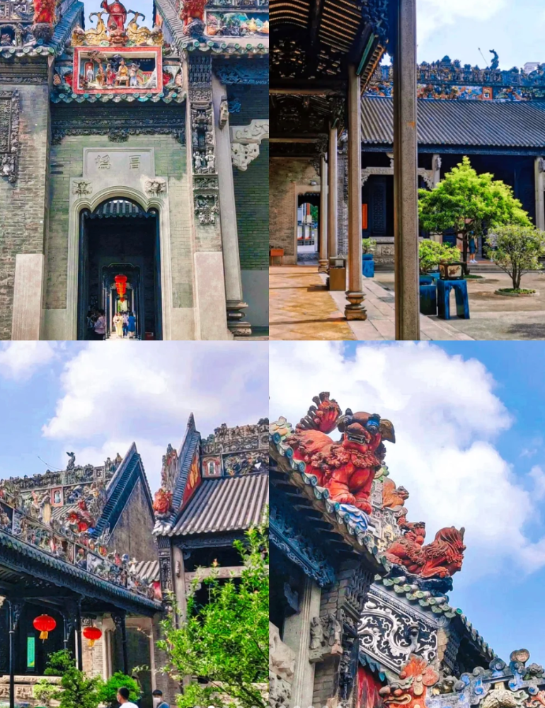
Chenjiaci Temple is a well-preserved temple-style building with a large scale and a characteristic Lingnan-style roof sculpture 🗿, which is worth visiting.
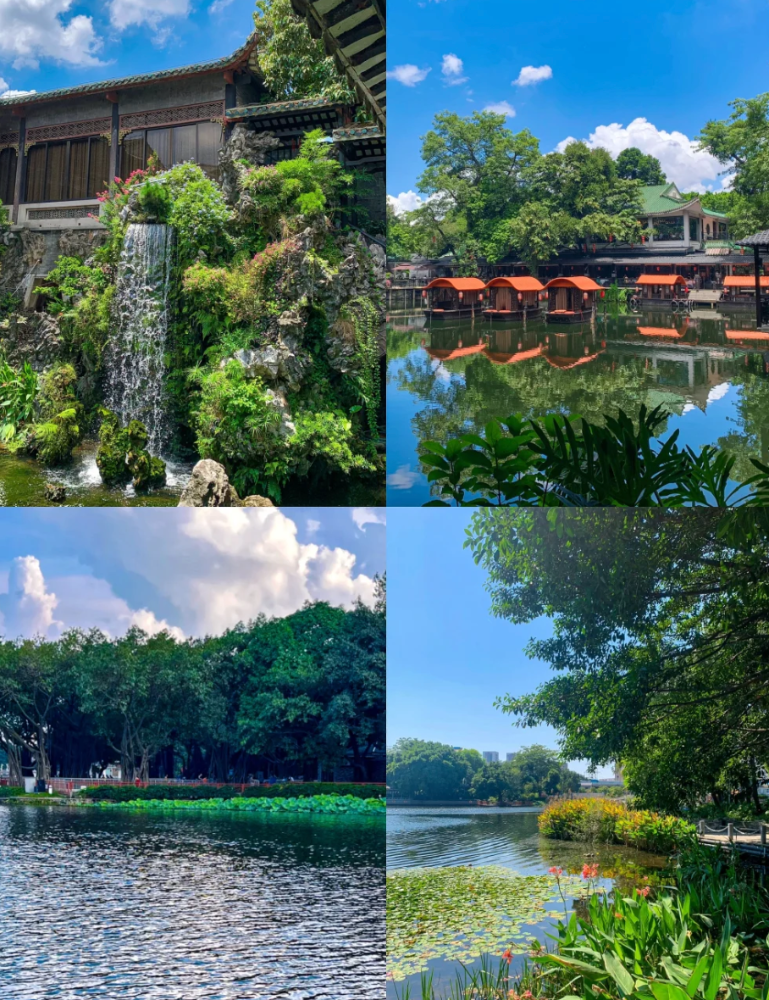
Liwan Lake Park has a strong Xiguan flavor 🌾, with bookstores 📚 and coffee shops ☕ that are very characteristic. The pavilions and corridors are very nostalgic.
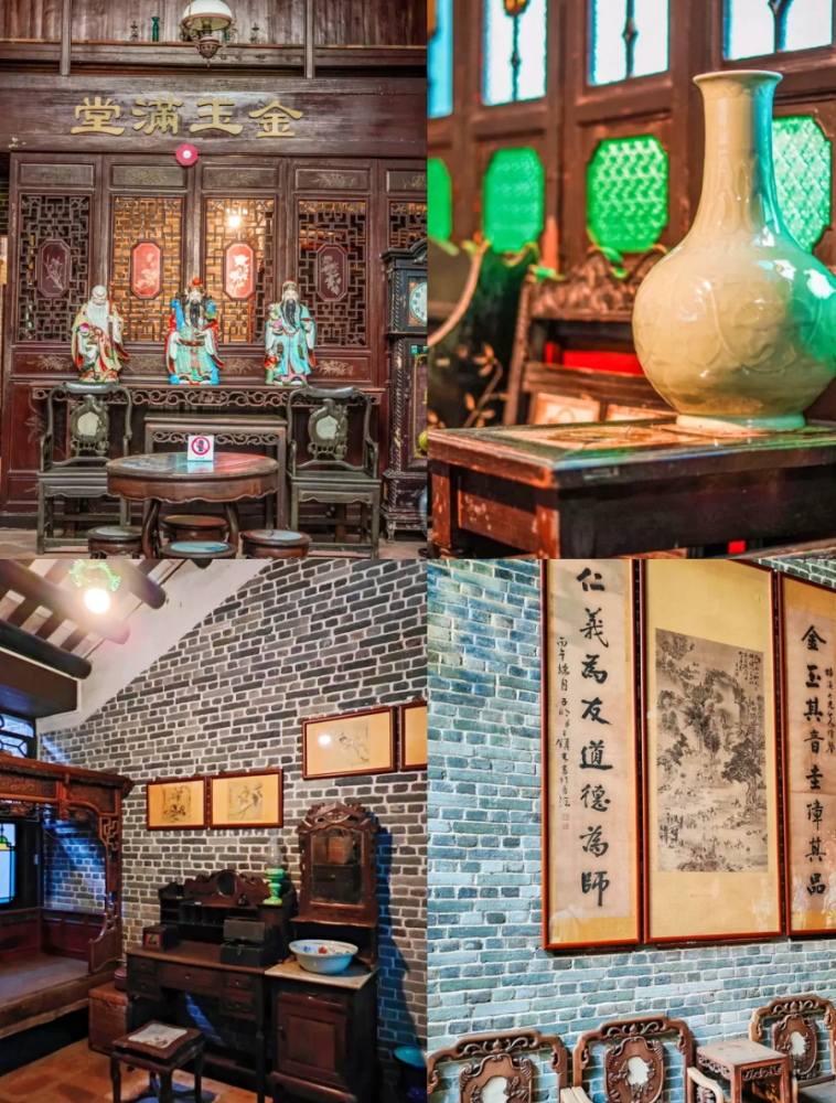
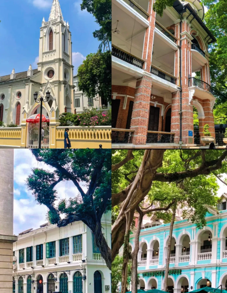
Xiguan Great House is like traveling back in time to ancient Xiguan ⏳, with furniture and scenery that have been restored to their original state.
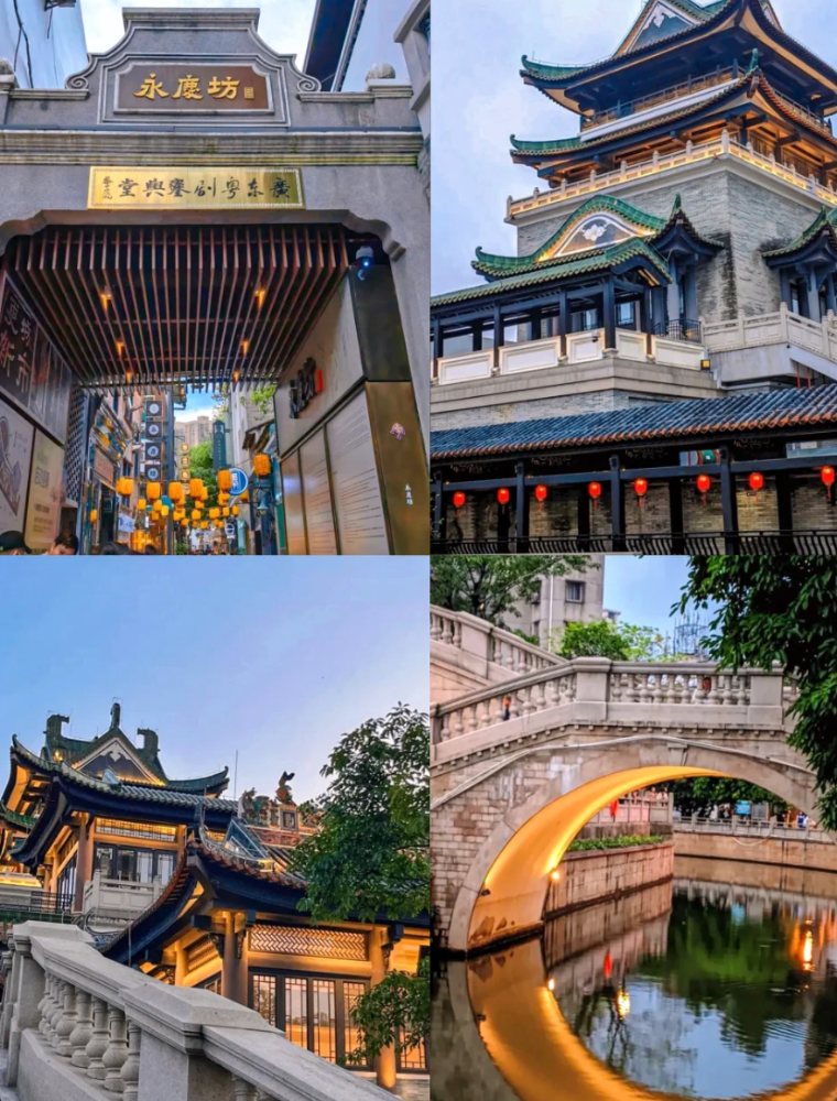
Yongqingfang has Bruce Lee's former residence 🏠, the Guangdong Opera Museum 🎭, and the Enning Road is known as the "most beautiful arcade street in Guangzhou" 🤩, with many cultural and creative shops.
Shamian Island was once a concession to Britain and France, with Tiffany blue European-style villas, Starbucks ☕, McDonald's 🍔, White Swan Hotel 🏨, and the HSBC building.
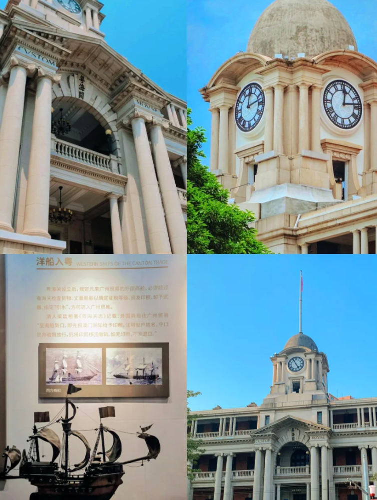
The Guangdong Museum of Foreign Trade is like a "small Bund", telling the story of the development of Guangdong's foreign trade since the Qing dynasty. Remember to book in advance 📲.
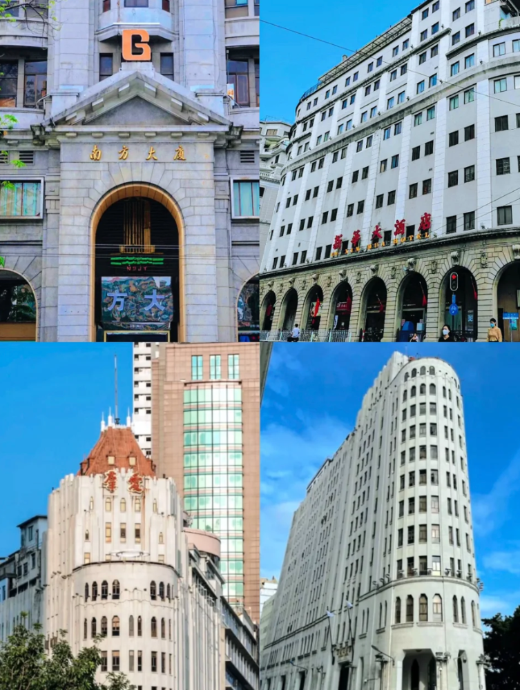
Jiangxi West Road has the earliest "skyscraper" in China, the Nanfang Building, and the clever combination of European and Lingnan-style buildings like the Ai Group Hotel 🏤.
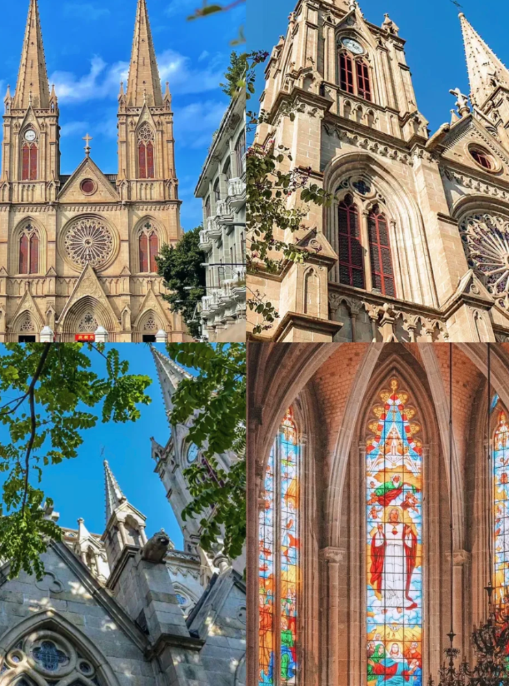
The Sacred Heart Cathedral is modeled after the Notre Dame Cathedral in Paris 🏰, one of the few Gothic-style buildings with twin spires in China, and a great spot for taking photos 📸.
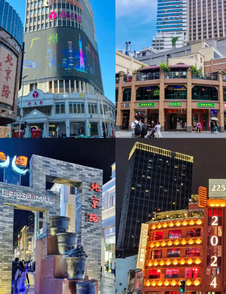
Beijing Road is a comprehensive area of food, commerce, and ancient architecture, a historic and characteristic commercial street 🏪 that can be explored and enjoyed.
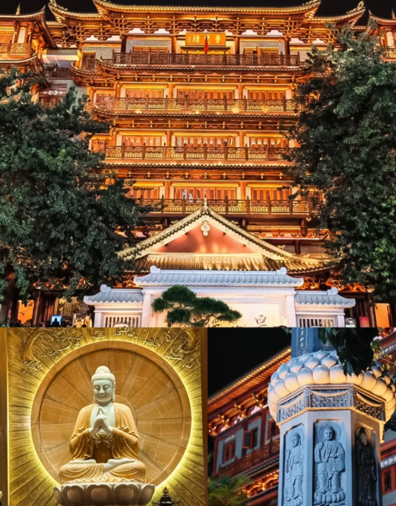
Dafo Temple has a thousand-year history, and the scenery at night under the light is simply like a scene from a movie 🌟.
Food:
1️⃣ Liwan Lake: Tang Liyuan and Panyu Restaurant for early tea 🍵, and Xiguan's Lingji.
2️⃣ Yongqingfang: Wu Caiji Noodle House 🍜, Enning Snow Ice Cream 🍦, Chen Tianji, and Ah Po's Beef Noodle Soup.
3️⃣ Beijing Road: There are many characteristic snacks that can be enjoyed while walking and exploring 💪.
Sign in to join the conversation
Sign InNo comments yet. Be the first to share your thoughts!
Tsim Sha Tsui (English name: Tsim Sha Tsui, also known as Tsim Sha Tsui), formerly known as Tsim Sha Tsui, was called Tsim Sha Tsui in ancient times and Xiangbu Tau in the old days. In the past, the area around Dongguan was full of fragrant woods. The juice squeezed from the roots of fragrant woods could be used as spices, called Wanxiang. Due to the convenient water transportation in Hong Kong, spices would first be concentrated in Tsim Sha Tsui, then shipped to Shek Pai Wan in Wong Chuk Hang on Hong Kong Island by ship, and then transported to the mainland by water. It had developed into a settlement in the Ming Dynasty. Tsim Sha Tsui is part of the Yau Tsim Mong District in Kowloon. It is located at the southern end of the Kowloon Peninsula. It is bounded by Austin Road to Hong Zhuang Road in the north, and faces Central and Wan Chai on Hong Kong Island across Victoria Harbour. From a geographical point of view, Tsim Sha Tsui is a cape at the southern end of the Kowloon Peninsula, adjacent to Hung Hom Bay. Before the land reclamation, the sea water near the area was blocked by Guanyong Mountain, and a long and sharp beach was formed at its southern end, which was very prominent in terms of topography. The original coastline of Tsim Sha Tsui is around Salisbury Road and Chatham Road. There were originally two parallel capes: Kowloon Cape and Blackhead Cape. There is also a small bay between the two capes. After many reclamation projects, Tsim Sha Tsui has increased a lot of land area, but it is still a highly developed area and has always been the heart of Hong Kong.
Leshan City (Sichuan dialect pinyin: No2san1; local pronunciation: [nʊʔ3sã55]), formerly known as Jiazhou and Jiading, is a prefecture-level city under the jurisdiction of Sichuan Province, People's Republic of China, located in the south-central part of Sichuan Province. The city borders Zigong City and Yibin City to the east, Liangshan Prefecture to the south, Ya'an City to the west, and Meishan City to the north. It is located in the southwest of the Sichuan Basin, with the Chengdu Plain in the north, the hilly area of central Sichuan in the east, and the Xiaoliangshan Mountains in the southwest. The terrain is high in the southwest and low in the northeast. The Minjiang River runs from north to south, merges with the Dadu River and the Qingyi River in the urban area, and then flows out of the city to the southeast. The total area of the city is 12,720 square kilometers, with a population of 3.2605 million. The Municipal People's Government is located in the Shizhong District. Leshan is a national historical and cultural city and an excellent tourist city in China. The famous Leshan Giant Buddha is located on the south side of Lingyun Temple on the east bank of the Minjiang River. Mount Emei, one of the four famous Buddhist mountains in China, is located in the northwest of the city.
Xuhui District, a district under the jurisdiction of Shanghai, is located in the southwest of Shanghai's central urban area. It borders Huangpu District to the northeast, Huangpu River to the east, Pudong New Area across the river, Minhang District to the west, and Jing'an District and Changning District to the north. The total area is 54.93 square kilometers [32]. The district has 12 sub-districts and 1 town under its jurisdiction, with a total of 306 neighborhood committees. The district people's government is located at No. 336, Caoxi North Road, Xujiahui Sub-district. [1] At the end of 2023, the total permanent population of the district was 1.1098 million, an increase of 1.0% over the previous year [51]. Xu Guangqi, a scholar of Wenyuan Pavilion in the late Ming Dynasty, established a farm near the confluence of Zhaojia River and Lijing River, engaged in agricultural experiments and wrote books, and cooperated with Italian and European missionary Matteo Ricci, creating a precedent for cultural exchanges between China and the West. Later, the Xu family settled here for generations, and the area was named Xujiahui, hence the name of the district. [48] The district has a northern subtropical monsoon climate with four distinct seasons. [52] Xuhui District is an industrial structure dominated by modern service industry, supported by industry, commerce and real estate. [54] Xujiahui in Xuhui District is the sub-center of the city in the southwest of Shanghai. Xuhui is one of the central urban areas in Shanghai that has basically completed the renovation of old districts earlier. Xuhui focuses on the development of high-tech industries such as information technology, modern biomedicine, and nano-new materials, forming an industrial scale for the development of industrial electronic information and biomedicine in the district. In 2024, the GDP of Xuhui District will be 393.12 billion yuan, and the district-level fiscal revenue will increase by 12.37% year-on-year. [90] In 2024, Xuhui District issued the "Shanghai Pilot Free Trade Zone Xuhui Linkage Innovation Zone Construction Plan", officially launching the construction of the "Shanghai Pilot Free Trade Zone Xuhui Linkage Innovation Zone"
Lijiang City, [21] is a prefecture-level city under the jurisdiction of Yunnan Province, China. It borders Liangshan Yi Autonomous Prefecture and Panzhihua City in Sichuan Province to the east, Jianchuan, Heqing, and Binchuan counties of Dali Bai Autonomous Prefecture and Dayao and Yongren counties of Chuxiong Yi Autonomous Prefecture to the south, Lanping County of Nujiang Lisu Autonomous Prefecture to the west and Weixi County of Diqing Tibetan Autonomous Prefecture to the north. [131] Lijiang City has a total area of 20,600 square kilometers, [132] and has one district and four counties under its jurisdiction. [19] Naxi, Mosuo, Yi, and Yunnan dialects are spoken in the city. [54] [119] As of the end of 2024, the permanent population of Lijiang City is 1.25 million. [220] Lijiang City is located on the southeastern edge of the Qinghai-Tibet Plateau, the northwest Yunnan Plateau, [20] and has a semi-humid low-latitude plateau mountain monsoon climate. [30] The rivers in the territory belong to two major river basins and three major water systems. In the Shu Han period, Lijiang was established as Suijiu County. In the Yuan Dynasty, the Chahanzhang Civil Affairs Office was first established, and later changed to Lijiang Xuanweisi, Lijiang Road Military and Civil Administration Office. In the early Ming Dynasty, Lijiang Prefecture was established. In the Qing Dynasty, Lijiang Military and Civil Affairs Office was established. In December 1949, Lijiang People's Administrative Commissioner's Office was established, and in April 1950, it was changed to Lijiang Commissioner's Office. [5] Lijiang City has an integrated comprehensive transportation system with roads as the main body, and railways, civil aviation, and water transportation connected. The transportation in the territory is convenient. [90] It is the political, economic and cultural center of northwest Yunnan, and a distribution center for materials on the "Southern Silk Road" and the "Ancient Tea Horse Road". [5] Lijiang City has three world heritage sites, [201] multi-ethnic and multi-religious coexistence, [29] above-ground and underground cultural relics are widely distributed, [128] and rich tourism resources. [59] As of 2021, there are 199 fourth-level cultural relics protection units. There are 11 national-level sites, 14 provincial-level sites, 56 municipal-level sites, and 118 county (district)-level sites. [11] There are 104 tourist attractions in the territory, with more than 13,000 species of animals and plants, making it one of the country's famous animal and plant protection bases. [219] Lijiang City has a variety of ethnic cultures and folk activities. For example, the Bangbang Festival and the Sanduo Festival of the Naxi people on the 15th day of the first lunar month, the Torch Festival of the Yi people, and the Kuoshi Festival of the Lisu people. [59] In 2024, Lijiang City will achieve a regional GDP of 71.003 billion yuan, an increase of 4.7% over the previous year.
A special administrative region in southern China, it is an international financial center and shopping paradise.
A province in southeastern China, rich in natural landscapes and unique culture.
A province in south-central China, Mao Zedong's hometown, famous for Hunan cuisine and Zhangjiajie scenic area.
The eastern coastal province of China, the hometown of Confucius, has rich cultural heritage and natural resources.