📍Shenzhen Observatory-Dapeng
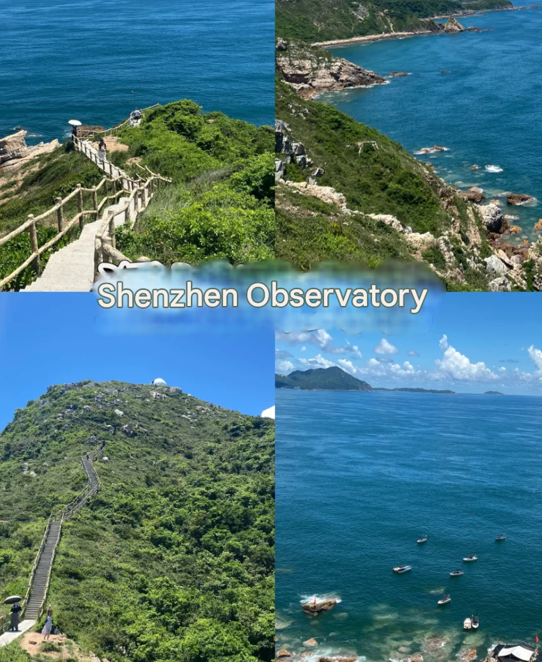
✅The most beautiful coastline recommended by National Geographic, half plank road, half sea
🚗: Drive to No. 4 Beach of Xichong Beach and transfer to a minibus to the top of the mountain
🎫: Free
🕒: 09:00-12:00 14:30-17:30 Closed on Mondays
📍Judiaosha-Dapeng New District
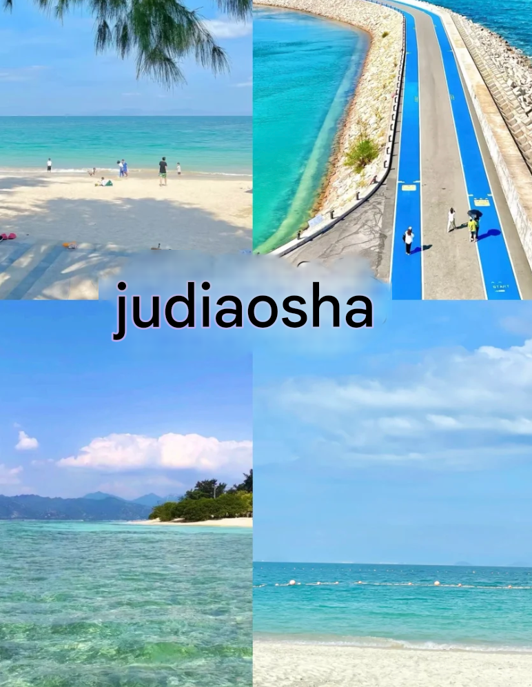
✅Shenzhen's Maldives, with a beautiful glass sea!
🚗: Bus M27 Judiaosha Station
🎫: Partially free
🕒: 24h
📍Luzui Villa-Dapeng New District
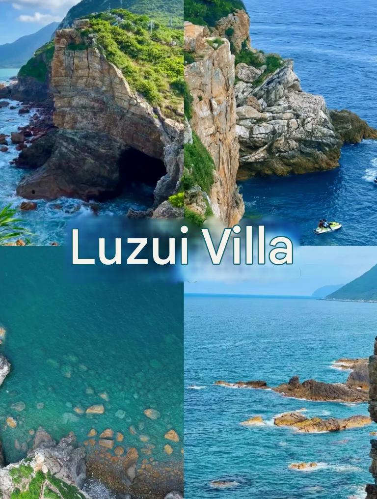
✅The filming location of the movie "The Mermaid", with valleys, cliffs, cliffs, reefs, and beaches
🚗: Take M274 to Yangmeikeng Station-take a sightseeing bus (13.8r) or a speedboat (30r) to Luzui Villa
🎫: Free
🕒: 6:00-18:00
📍Yougan Bay-Longgang District
✅Yougan Bay, located on the Nan'ao Peninsula, faces the sea. It is a natural deep-water bay, a super niche glass sea, and comes to It feels like being in Hawaii here, with a sparkling glass sea
🚗: Take E11 to Dapeng Moon Bay, then take a taxi to Nan'ao Yougan Bay Royal Resort Hotel
🎫: Free
🕒: 8:00-18:30
📍Yunhai Square-Yantian District
✅Shenzhen version of the Sky City
🚗: Sanzhoutang Reservoir Yunhai Park Observation Deck (Metro Line 8 Haishan Station Exit B2, take the Yunhai Special Bus)
🎫: Free
🕒: 8:30-18:00 (You can enter the Yunhai Square Library)
📍Shenzhen Bay Park-Nanshan District
Highlights: Siberian seagulls have flown back to Shenzhen! ! Orange sunset at the seaside with coconut trees
🚗: Exit D2 of Shenzhen Bay Park, Line 9
🎫: Free
🕒: 6:00-23:00
📍Shenzhen Happy Harbor-Bao'an District
✅Shenzhen's new landmark, with the popular "Light of the Bay Area" Ferris wheel, overlooking the beauty of the entire Bay Area
🚗: Exit B2 of Linhai Station, Line 5
🎫: Free
🕒: 24h
📍Qianhai Stone Park-Nanshan District
✅Check in at the giant milk dragon, the Ferris wheel lights up at night and is also very beautiful, suitable for picnics and camping
🚗 : Exit E of Guiwan Station on Metro Line 5
🎫: Free
🕒: 24h
📍Sea World-Nanshan District
✅Super chill seaside exhibition hall and cruise
🚗: Exit A of Sea World Station on Line 2
🎫: Free
🕒: 24h
📍Xianhu Botanical Garden-Luohu District
✅Alternative version of Altay🌲Weekend oxygen inhalation and charging holy place
🚗: Exit C3 of Xianhu Road Station on Line 2/8
🎫: 15/person
🕒: 06:00-18:00
People who see this guide will become rich and thin! !
Explore more treasure places with me~
Sign in to join the conversation
Sign InShenzhen is indeed a city suitable for family travel. I took my children to Window of the World and they had a lot of fun.
Zhangjiajie City, formerly known as "Dayong", is a prefecture-level city under the jurisdiction of Hunan Province. It is one of the most important tourist cities in China, a national key ecological functional area, and an important ecological barrier in the middle and lower reaches of the Yangtze River. The city has two districts and two counties under its jurisdiction, namely Yongding District, Wulingyuan District, Cili County, and Sangzhi County, with a total area of 9,533 square kilometers. [51] At the end of 2024, the permanent population of Zhangjiajie City was 1.4869 million. [90] Zhangjiajie City is located in the northwest of Hunan Province, in the middle and upper reaches of the Lishui River, and belongs to the hinterland of the Wuling Mountain Area. [1] It is the birthplace and central area of the Hunan-Hubei-Chongqing-Guizhou Revolutionary Base. It was built for tourism. It is the window of Hunan's opening up, the living room for welcoming guests, the leader of all-region tourism, and the beautiful business card of Beautiful China. It is known as "an enlarged bonsai and a shrunken fairyland". [51] In September 1982, Zhangjiajie National Forest Park became China's first national forest park. In August 1988, Zhangjiajie Wulingyuan Scenic Area was listed as a national key scenic spot. In 1992, the Wulingyuan Scenic Area, which consists of three major scenic areas including Zhangjiajie National Forest Park, was listed in the World Natural Heritage List by UNESCO; in February 2004, it was listed in the world's first batch of World Geoparks; in 2007, it was listed in China's first batch of national 5A-level tourist attractions. [2] In 2017, Zhangjiajie City was awarded the honorary title of "National Forest City". [3] In 2024, Zhangjiajie City achieved a regional GDP of 65.44 billion yuan, an increase of 3.9% over the previous year.
The political and cultural center of Beijing, with many government agencies and cultural institutions. Xicheng District, under the jurisdiction of Beijing, is located in the central area of western Beijing. It is adjacent to Dongcheng District in the east; Haidian District and Chaoyang District in the north; Haidian District and Fengtai District in the west; and Fengtai District in the south. The district is 7.1 kilometers wide from east to west and 11.2 kilometers long from north to south, with a total area of 50.70 square kilometers. As of January 2025, Xicheng District has 15 sub-districts and 263 communities under its jurisdiction [39] [66]. As of the end of 2024, the permanent population of Xicheng District is 1.095 million. [70] Xicheng District is the site of Jicheng, the capital of Yan during the Warring States Period, and was part of the capital during the Liao, Jin, Yuan, Ming and Qing dynasties. As the place where Beijing was built for more than 3,000 years and the capital for more than 800 years, it is a fusion area of royal culture and folk culture, and an area where various cultures such as imperial city culture, official culture, folk culture, and religious culture are highly integrated [2]. Xicheng District has many scenic spots, including Yuetan Park, Temple of Successive Emperors, Taoranting Park, Beijing Grand View Garden, Prince Chun Garden, Prince Gong Mansion Garden, etc. In 2024, Xicheng District will achieve a GDP of 603.8 billion yuan, of which the added value of the secondary industry is 30.27 billion yuan and the added value of the tertiary industry is 573.54 billion yuan. Calculated based on the permanent population, the per capita GDP of the district is 550,000 yuan (converted to 77,000 US dollars at the annual average exchange rate).
Kashgar City (Uyghur: قەشقەر شەھىرى) [10] is a county-level city under the jurisdiction of Kashgar Prefecture, Xinjiang Uyghur Autonomous Region. It is located in the southwest of Xinjiang Uyghur Autonomous Region and the western edge of the Tarim Basin. The terrain is high in the north and low in the south. It has a warm temperate continental arid climate with four distinct seasons and a total area of 1,528.84 square kilometers. [11] As of 2024, Kashgar City has 10 sub-districts, 3 towns, and 12 townships. As of August 2020, Kashgar City has a permanent population of 700,000. [20] Kashgar is the abbreviation of "Kashgar". "Kashgar" means "jade" in Turkic and "Gar" means "stone" or "mountain" in ancient Iranian. Before Kashgar was incorporated into the territory of the Central Plains regime, it was often part of the Shule Kingdom. It was not until Zhang Qian's mission to the Western Regions that official exchanges between Kashgar and the Central Plains began. In the third year of Yongping in the Eastern Han Dynasty (60 AD), the Western Regions Protectorate was established, and Kashgar, as part of the Western Regions, was officially included in China's territory. In 1952, Kashgar City was officially established. Kashgar City is a national historical and cultural city, a national open city, an excellent tourist city in China, and a national model city for the military-civilian integration. It is the westernmost border city in China and the political, economic and cultural center of the Kashgar region. It is an important commercial port on the Silk Road, a hub for east-west transportation, and an important intersection of the economy, culture and civilization of the East and the West. Kashgar International Airport is a first-class aviation port open to the outside world. In October 2020, Kashgar City was named a national model city for the military-civilian integration. [1] In 2023, Kashgar City achieved a gross domestic product (GDP) of 30.931 billion yuan, an increase of 9.6% over the previous year.
Dali City (Bai: Dallit sil) is a county-level city in Dali Bai Autonomous Prefecture, Yunnan Province, People's Republic of China, and is also the capital of Dali Prefecture. It is located in the western part of Yunnan Province, China, on the Yunnan-Guizhou Plateau, at the foot of Cangshan Mountain, and on the shore of Erhai Lake. The city covers an area of 1,739 square kilometers, with a total population of 771,100 in 2020. The Municipal People's Government is located in Haidong Town. Dali City is a national historical and cultural city[6], an excellent tourist city in China, a national garden city[7], and a national comprehensive tourism demonstration area[8]. In ancient times, it was the capital of Nanzhao Kingdom and Dali Kingdom successively. It is one of the earliest developed regions in Yunnan Province and has served as the political, economic and cultural center of Yunnan for more than 500 years.
A province in northwestern China, with natural landscapes such as Qinghai Lake and rich Tibetan culture.
A province surrounding Beijing and Tianjin, rich in history, culture and natural landscape.
China's northernmost province, with rich forest resources and snow and ice landscapes.
A province in southeastern China with famous attractions such as Mount Lushan and Mount Sanqingshan and rich porcelain culture.